::: Importing Maptech PCX or RML Charts ::: Байк, велотуризм, экипировка :::
RealBiker

ВЕЛОСИПЕД | НАВИГАЦИЯ | ЗИМА | СТАТЬИ | ОТЧЕТЫ | ДР САЙТА | КАЛЕНДАРЬ beta
ФОРУМ (Архив) | СООБЩЕСТВО | ДАЙДЖЕСТ | exГАВ | НАХОДКА
РЕМОНТ ВЕЛОСИПЕДОВ | УСЛУГИ | ССЫЛКИ | RealПОИСК | КОНТАКТЫ

  > НАВИГАЦИЯ > OZIEXPLORER > ДОКУМЕНТАЦИЯ > Importing Maptech PCX or RML Charts

Спонсорские ссылки

OziExplorer

Документация

[ содержание ]

Importing Maptech PCX or RML Charts

This option is on the File/Import menu.

This option is used to import Maptech PCX charts, these charts have a .HDR file extension (which is what you import) and a series of files with the extensions of .A01, .A02.... etc. Maptech RML charts (Superdisks) are also imported with this option. These charts have a .RML file extension.

The process involves scanning the chart files on the CD and creating OziExplorer .map files for each chart. The .map files are saved on the hard disk in the path specified. It is these map files which are used to open the charts into OziExplorer.

The map images are not moved from the CD so the CD needs to be in the drive when the map files are opened.

This Import option does not apply to Maptech BSB charts, these are imported using the separate BSB Import options on the Import menu.

wMaptechImport.gif (5572 bytes)

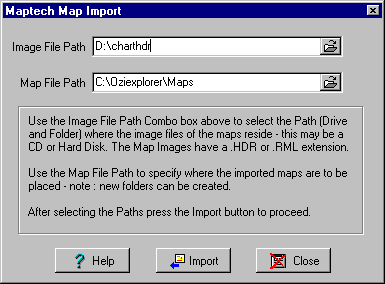
Image File Path - The Path where the chart files are located, for PCX charts this is the path where the .HDR files are located and is usually the charthdr folder on the CD. For Superdisks this is where the .RML files are located.

Map File Path - The path where you want the OziExplorer .map files to be placed, it is these files you will use to open the map in OziExplorer.

Import - Imports the maps and creates the OziExplorer .map files. The .map files can then be loaded from the map file path using the Load Map from File option on the Load button on the Toolbar. The map image files are not moved and must be available from their original location (usually the CD).

[ содержание ]

Хотите стать спонсором раздела?

КАРТЫ

Архив
Бумага
Иные
материалы
Бланковые
карты
Карты
в Сети
Данные из космоса

ЖЕЛЕЗО

Отзывы
Мысли
FAQ
Аксессуары

СОФТ

OziExplorer
NameSearch
Генератор номенклатуры

ТОЧКИ

База точек
Природные
и культурные
объекты
Маршруты

ПРОЧЕЕ

Топосимволы
Сокращения
О картах
Лучшие фотки по оценкам пользователей:Находки:
О как размесили =). 
 (альбом Все что успел наснимать)А финишная черта - доплюнуть можно буквально!. 
 (альбом 9-летие нашего сайта)Брод через Москва-реку. Несут Рейсера.. 
 (альбом 9-летие нашего сайта)Без названия. 
 (альбом Холщевики-Тучково)Анатолия 2011. Тахталы повержена. 
 (альбом 2 недели рая)

Из комментариев к фоткам: Хе-хе))) А что случилось?)

Нашли что-то интересное или полезное? Поделитесь! =)

© Anton Chubchenko, 1999-2016


Автор не несет ответственности за использование информации и программ, содержащихся на ресурсе http://realbiker.ru.
Вся представленная информация является интеллектуальной собственностью автора(ов).
Недопустима публикация в сетях и иных источниках и/или коммерческое использование без согласия автора(ов).
По вопросам рекламы на сайте обращаться сюда.
Спонсорская поддержка сайта.
Яндекс цитирования
Спонсорские ссылки